Featured

Why walk the Fife Coastal Path?

There are many reasons to walk the Fife Coastal Path – the amazing views across the river Forth; the bracing sea air; the beautiful flowers and trees; and the lovely people you meet along the way. Oh, and the cosy cafĂ© stops, of course.

I have been living in Fife most of my life and only discovered the Fife Coastal Path last year! While my daughter, Carys, was at a gymnastic club in Kirkcaldy I decided that the couple of hours I wasted wandering around Asda or drinking coffee in Costa could be put to better use. I knew the coast was nearby so I started to explore some of the little villages around the coast going eastwards from Kirkcaldy. And what a lovely surprise!

I started with Dysart –  with its lovely harbour and row of white washed cottages along the sea front with that foreboding tower looming behind them what’s not to love:

IMG_2871
IMG_2876

And of course, The Harbourmasters House where you can get a lovely coffee and a cake  (or two) as well as learn about the history of the Fife Coastal Path and things to see and do:

IMG_2873

Visit Scotland – The Harbourmasters House, Dysart

I remember the first day I came to Dysart, the sun was shining over the still water and I sat on the rocks, reading a book, looking up every now and then at the perfection in front of me. How happy and content I felt sitting there in the sunshine. I took my grown-up son down one day and my not-so-grown-up daughter and they loved it too:

IMG_2960

From that day on I was hooked. I discovered Ravenscraig park in Kirkcaldy led onto the Fife Coastal path and was only a mile from Dysart. The first time I walked through the park and down some steps to join the path I was met by this!

IMG_2861

Ravenscraig Dovecot!

And then there was the fortified walls along the coast:

IMG_2862

And lovely flowers and trees:

IMG_3975[1]

Not to mention the majestic sculpture just behind Dysart harbour where seagulls love to perch:

IMG_2874

From my beginnings at Dysart I have since visited, West Wemyss, Buckhaven and Leven then started exploring closer to home in North Queensferry, Inverkeithing, Dalgety Bay Aberdour and Kinghorn. I also did the start of the Fife Coastal Path from Kincardine to Culross.

So, why am I writing this blog? Well, I decided I wanted to do something to raise money for two charities that I have used last year and this year. To give something back. How better a way to raise money than by doing something you love. So I plan to walk the entire 117 miles of the Fife Coastal Path over 6 or 7 days starting next Tuesday 5th July. I plan to record my journey every evening just in case someone else decides they might want to follow in my footsteps. Hopefully I can provide some tips on where to stay, where to eat and drink and where to pee:-) And some more lovely pictures!

Have you already walked the Fife Coastal Path? Do you have any advice for me? Or do you enjoy walking in any other parts of Fife? I would love to hear from you. Please leave a comment using the link below. Thanks for reading!

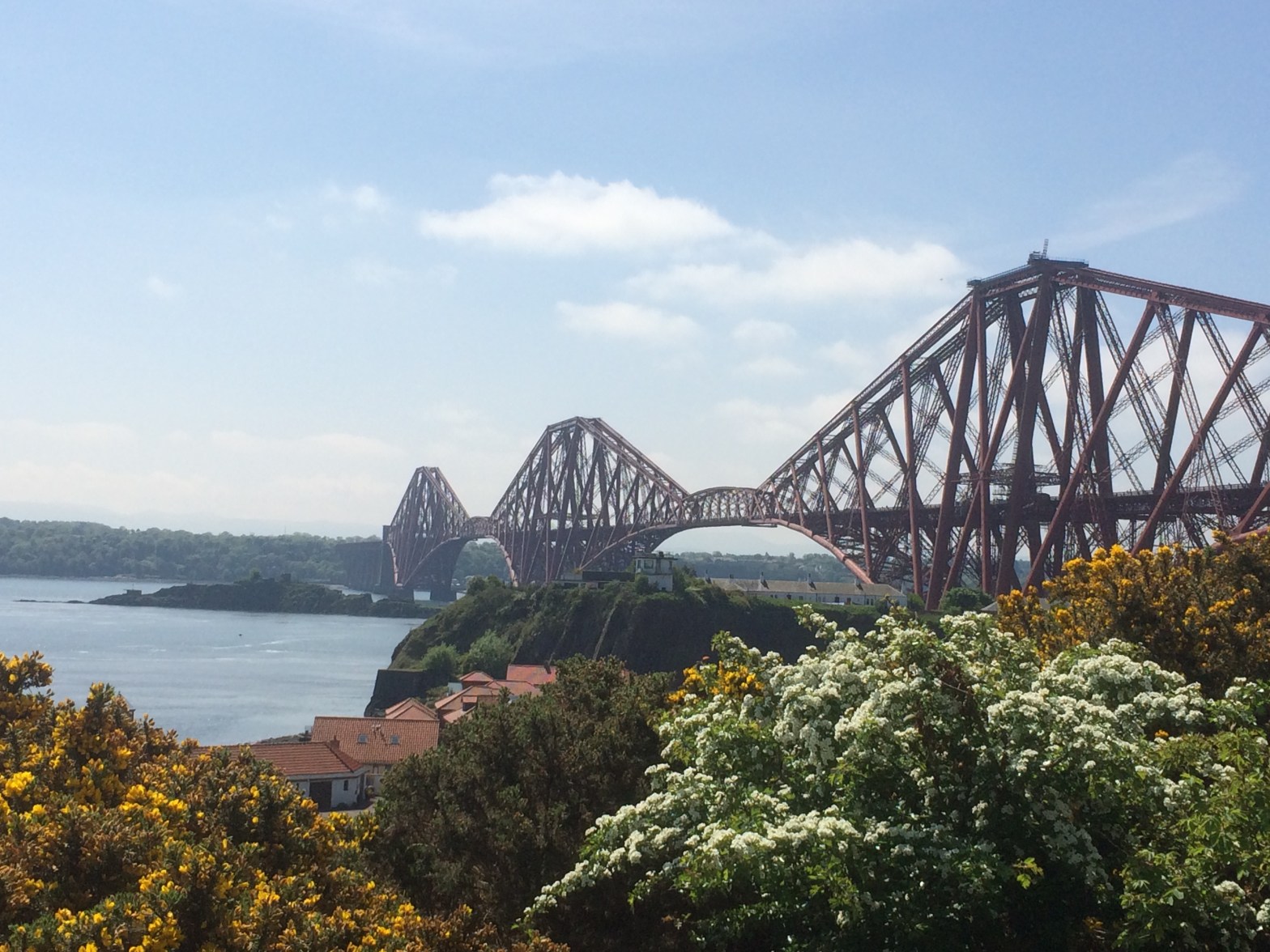
Day 1 – Kincardine to Inverkeithing

Ok, so I got lost! For those of you who know me I’m sure this is no surprise:-)

It all started so well. It didn’t rain; I met a lovely wee dog called Alf who was really keen on getting his photo taken (couldn’t keep his tongue in his mouth though:-( ):

IMG_4186

and some more friendly animals:

and even some friendly advice:

IMG_4191

The problem came after I’d passed by Culross (definitely worth a visit if you haven’t been there – it’s lovely) and was trying too get to Low Valleyfield. There is a point when a bridge crosses the path above you – do not go under this bridge! That is where I went wrong.

Before the bridge is a sign. You must turn right at that sign, down a wee path and over the bridge into Low Valleyfield. I completely missed it and walked for ages until I came to a big locked metal gate and had to walk back again! I must admit there were some warnings:

After a bit of a panic and some directions from a kind couple walking their dogs all was well again, phew!

IMG_4210.JPG

So, getting back to the walk (before the mishap) I would definitely stop in Culross:

There are nice places to eat and drink, for example, The Red Lion Inn and The Biscuit CafĂ©. And public toilets too. (Of course, I didn’t do this and had to ask to use the facilities of a pub in Newmills:

IMG_4213.JPG

After Newmills there is Torryburn, Crombie and Charlestown. My family met me at The Elgin Hotel where we had a lovely lunch. Definitely recommend that too. The walk is quite straight forward with lots of pretty flowers, trees and cottages:

But be careful when you start going towards Rosyth. Don’t take this right turn:

IMG_4232

Just after this a bit up the hill is this tiny wee sign and a tall sign opposite where you have to turn right:

This takes you up a path and through a kind of open grassy area where people walk their dogs. When I came out of the park there were no signs and I didn’t have a clue where to go but I turned right and walked down to the bottom of the hill ( the street is Wilson Way) where luckily I found another sign letting me know I was in the right place.

On the path from Rosyth there is an ancient hidden Doocot ( a house for pigeons apparently):

IMG_4240

And then on to North Queensferry ( I stopped in The Queensferry Lodge Hotel for the toilet) there was a great view of the new bridge:

IMG_4242

And the old bridge:

IMG_4246.JPG

In north Queensferry the signs for the path point left but are a bit squint! Make sure you go tight left and up the wee hill then a quick right into a lane. Its easy to miss!

It’s a lovely walk along the coast from North Queensferry to Inverkeithing with views over to Dalgety Bay:

IMG_4247

When you get to Inverkeithing you have to walk up the high street. There are lots of places to eat and drink here and don’t forget to look out for the ancient Mercat Cross!:

And that’s it for today. 19 miles in all. It should make an easy day for tomorrow since I’m ahead of schedule. I’ve been so lucky with the weather and seen lots of lovely things. I hope this will help you not to get lost like I did today if you ever decide to do the walk yourself. Any questions, just ask, using the comment box below. Thanks for reading!

Day 2 – Inverkeithing to Dysart

I must admit I was a bit confused this morning when I was eating my porridge but that’s probably not unusual:-)

You see, when I decided to do this walk, I planned each day so that they would be around 16 miles each to split the whole walk over 6/7 days. I used the Official Guide you can see in the picture above which has around 24 sections but I put a few together and worked it all out perfectly – or so I thought.:-)

My friend Mary recently told me about the detailed mile by mile map (also seen above) so I bought one of those a couple of weeks ago (I bought both from The Harbourmaster’s House, Dysart). So I have been using the detailed map when doing the walk.

I was so chuffed with myself walking extra miles the first day (19 instead of 16) because I knew I would have a heavier bag today to carry since I wasn’t going home. And then, when I looked at the detailed map this morning it indicated that I would start today at Inverkeithing (which is mile 19) and Dysart was mile 37!! That meant today was another 18 miles! How did that happen?! So it’s fair to say I’m a bit knackered tonight and my toes feel a bit battered but I got here  in time to see the end of the Andy Murray match so what more could I want:-)

To add insult to injury my 16 mile walk set for tomorrow has now turned out to be 21 miles! On the detailed map Dysart is at mile 37 and St. Monans 58! I better get up early:-)

Anyway, moan over. It’s been a lovely day today and I didn’t even get very lost, hurray!

I started at the Mercat Cross in Inverkeithing where I finished yesterday. Just after the cross you turn down to the right (Bank Street) and then right again at the bottom of the hill. The signs are a bit confusing but I’d been here before:-)

It’s interesting to note how different the sounds are around you when you’re walking the Fife Coastal Path. Through the towns there’s the normal traffic noise, and since most of the path is through woody areas, the most usual sound is the constant chit chat of all the different birds but yesterday I noticed how different it was going past Rosyth dockyard and today in Inverkeithing with their industrial noise – hammering, drilling and other machinery. In contrast Dalgety Bay is very quiet – the birds even seem to be very subdued.

So what did I see today? Well, after passing through Inverkeithing I quickly recognised Dalgety Bay in the distance and came across this big stone by the shore:

IMG_4252

Strange isn’t it? What possible use could that have? Any ideas anyone? I tried googling it but didn’t find anything.

Last year my sister and I were walking in Dalgety Bay and met a man who was getting his house built on the sea front overlooking the bridges. He was so excited about it and showed us all the design plans etc. Every time I go to Dalgety Bay I’m excited to see how far they’ve got with the build and today was no exception. Here’s the house now, they’re nearly there!

IMG_4255.JPG

The Coastal Path goes past this house then in to the right into the wooded area around the coast. The ground is rougher here and more varied so it gets you warm:-)

Lovely though isn’t it?

There are lots of lovely houses on the front (I’m so jealous):

IMG_4260

And this lovely building but I’m not sure what it is:

IMG_4261

You’ll go past the sailing club and a radioactive beach – just don’t go fishing for your tea there!

And you’ll see the ruins of a very old church:

And as you walk round the coast taking in the spectacular views, just as you begin to  feel tired and in need of a rest, the first glimpses of a golf course let you know that Aberdour isn’t far away:

Today I stopped at The Woodside Hotel and had the best cup of coffee and homemade shortbread biscuits I think I’ve ever had!

From Aberdour high street you turn down right to the black sands. Oh how peaceful it is down there. One of my favourite places to sit with a book.

As you walk past the harbour and around the coast,

if you reach the sea food restaurant ‘A Room with a View’, you’ve gone too far. At the point where there is a sign pointing to the restaurant is where you have to turn up and climb the narrow stone steps onto the cliffs above to take you over to The Silver Sands:

At the Silver Sands there is also a nice Café and public toilets.

Carrying  on past the cafĂ© you follow the path under the railway bridge (very muddy!):

past a waterfall:

IMG_4315

and on to Burntisland (great poster!)

I would definitely recommend Potter About for lunch. Their food is amazing and you can have a go at painting some pottery if you like that sort of thing:-)

Today the tide was in after lunch so I had to carry on down the main road in Burntisland past Pettycur Bay caravan site (good for a cuppa or food and the loo) and on to Kinghorn. Watch out for the right turn down into Kinghorn bay. It’s just after this sign on the main road:

IMG_4328.JPG

If you keep going on the main road you bypass Kinghorn altogether. So turn right, its so worth it!

Coming out of Kinghorn the path to Kirkcaldy is very rough and hilly over the top of the cliffs. You have to be careful not to look down sometimes. It’s really beautiful though with lots of flowers on one side and the sound of the gently lapping waves on the other.

When you get to the Seafield Tower you know you are nearly at Kirkcaldy and boy was I glad to see it today:-)

IMG_4347.JPG

And even happier when I saw Kirkcaldy in the distance – didn’t think I’d ever be so happy to see Morrisons:-)

IMG_4349

After a drink and a rest in Morrisons I knew it was only around three miles to Dysart, along the esplanade in Kirkcaldy, up the big hill and into Ravenscraig park and along the path to Dysart. I thought this plaque was funny at the end of the esplanade in Kirkcaldy:

IMG_4351.JPG

It’s been a long but enjoyable day walking the Fife Coastal Path and I’m here now all cosy in my room in Merchant House B&B in Dysart. The rooms are big and clean and at only ÂŁ38 pound a night including breakfast I think its a bargain.

IMG_4354

Time for bed! Looking forward to tomorrow and the things I will see from here to St. Monans. Thanks for reading!

Day 3 – Dysart to St. Monans

What a lovely day today has been! Like summer!:-)

As you can see from the Dysart clock above (did you know it was built in 1576!) I left Dysart at around 9:30am. The sun was already shining and it was warm. The walk from Dysart to West Wemyss is quite hilly with a few sets of steep stairs both upwards and downwards so I was even warmer by the time I got there.

Here are some of the lovely things I saw along the way:

IMG_4368IMG_4369IMG_4367IMG_4366IMG_4365IMG_4362

West Wemyss is a really lovely village with a pretty harbour (not as pretty when the tides out I must admit) well-used by the locals; many ancient buildings that look like small castles and amazing overhanging rock formations that look like they are about to slide down on top of you:

IMG_4370IMG_4375IMG_4373IMG_4374IMG_4376IMG_4371

That last house above (the white one above the rock formation) is weird. Its empty so all the windows have been painted in! Its just black paint with white paint for the frames. It’s a bit spooky:-)

I thought this sign was quite funny in West Wemyss:

IMG_4377.JPG

I hadn’t been to East Wemyss before and didn’t think there was much there but was quite surprised at how nice it was too.

There was…

IMG_4379

…the scrap yard:-) This was the first thing I saw so didn’t hold up much hope for it but it got better.

New houses along the front,

IMG_4381.JPG

and old houses that were even nicer (this ones for sale by the way):

IMG_4385.JPG

and Budda houses!

IMG_4390.JPG

There were memorials neatly laid out for people who are no longer with us:

There were ancient caves,

and a ruined castle (Macduff Castle I believe):

IMG_4396.JPG

It was quite a steep climb out of East Wemyss then you get to the sign that says ‘Path to Buckhaven.’ Make sure you take the gravel path that leads to this lovely woody path – don’t go onto the main road (and no I didn’t before you ask:-) ).

But unfortunately I did go a bit wrong when I got to Buckhaven:-) After mile 42 I was supposed to turn right somewhere to get back down to the coast but must have missed it and stayed on the main road therefore I missed Methil and continued straight onto Leven – sorry Methil, nothing personal, I was probably texting or something:-) I was soon back on the path again once I reached Bawbee Bridge ( I was singing that song all afternoon about a child sitting on their mums knee wanting a ‘wee bawbee’ to buy some coulters candy – remember? Anyone? No, just me then:-) )

Things I saw in Buckhaven ( didn’t take many photos, I think I was trying to work out where I was:-) ).

Buckhaven Bay, past and present:

A nice church and a very old hospital:

And doesn’t this mess with your head:-)

IMG_4403.JPG

Anyone lost a cucumber?:-)

IMG_4410.JPG

Sorry, back to the Fife Coastal Path.

By the time I got to Leven I was roasting hot, hungry, thirsty and bursting for the loo so I just went into the first café I could find (I think it was Stuarts Bakers) so no tips on eating in Leven really just that there are loads of places so you wont be short.

Leven has a massive beach that leads on to Lower Largo and Largo Bay so after lunch it was a case of walking along the beach for miles – even I couldn’t get lost there:-) It was really lovely!

Lower Largo:

Lower Largo is apparently famous as the birthplace of Alexander Selkirk who was the inspiration behind Robinson Crusoe. There is a statue above the door of the house I assume where he was born:

IMG_4419.JPG

After the detour through the streets of Lower Largo the path takes you back down to the beach again (there are public toilets there if necessary:-) ). The beach seemed to go on forever!

But I was on a mission. My family were doing the Elie Chain Walk so I wanted to meet them afterwards for a coffee. I knew from Lower Largo it was another 6/7 miles to Elie so I still had a lot of walking to do. Eventually, I got to the end of Largo Bay to discover the tide had come in and blocked me in with it. I had to go back the way I came over the sand dunes across a couple of bridges just to get back to where I was – so watch out for the tides!

Once I navigated round the dunes then the path took me around a caravan sight and up over the cliffs. Its quite a long and strenuous walk (six miles uphill then steep downhill again with narrow paths and long grasses). But lovely views:-)

And after a bit of a hike around a golf course and through Earlsferry look who I found in The Ship Inn:

IMG_4440

IMG_4443.JPG

We had a lovely coffee in here as all the other cafes were closing (it was only 5pm!)including my  ice cream shop!

IMG_4439

After a well earned rest and a good catch-up the family had to rush off to take Carys to gymnastics but I knew I only had 2-3 miles left to get to St. Monans where my 21 mile walk was finishing for today. And what a lovely to finish! Walking round the coast from Elie to St Monans is simply amazing!

And some first glimpses of St.Monans (church and harbour)

To top an already perfect day my friend Mary and her daughter came to meet me on the last mile or so of today’s trek and treated me to tea! Thank you Mary!

IMG_4469.JPG

And now I’m writing this blog in my lovely B&B Grannies Harbour. Look at my view:

Its been another great day walking the Fife Coastal Path. Roll on tomorrow!


Day 4 – St. Monans to Boarhills

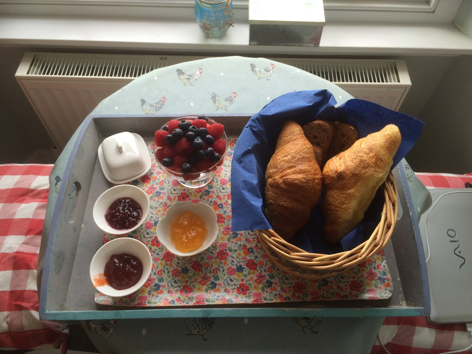
I was woken this morning with a gentle knock at my door and when I opened it this lovely breakfast had been left for me – delicious! As I sat at my window eating my breakfast looking out at St. Monan’s harbour I didn’t want to leave! There’s lots to love in St. Monans:

St. Monans harbour:

IMG_4478

St. Monan’s quaint houses:

IMG_4479

St. Monan’s rugged coastline:

IMG_4486

St. Monan’s Windmill:

IMG_4481

And St. Monan’s history (ruins of the saltpan houses where salt was manufactured from sea water):

You can see all of these things as you make your way out of St. Monan’s along the coastal path to the next village – Pittenweem.

Pittenweem is only about one and a half miles away from St. Monans so you reach it pretty quickly. The two villages are very alike with their ancient houses and pretty flower displays (there are a lot of bicycles decorated with flowers in Pittenweem but for some reason I failed to get a picture of them!),

but Pittenweem definitely wins in the ‘inviting little coffee shop’ stakes.

IMG_4494

And this one was so inviting I felt compelled to go in, although I hadn’t long had breakfast!

I was feeling pretty tired after yesterdays hike over the cliff tops from Lower Largo to Elie and fighting with hay fever constantly because of the long grasses made it worse (I meant to mention in yesterdays blog  – if you suffer from hay fever, make sure you have anti-histamine with you on this walk) . So, the plan of action was – get antihistamine at a chemist in Pittenweem then on to the next village, but the smell of coffee drew me inside. And I am so glad it did! In here I met a very nice man called John.

IMG_4496

John has lived in St. Monans with his wife, Stephanie for the past 3 years, coming here all the way from Whidbey Island in the Pacific North West of America. He told me how enjoys walking every day and often walks to Pittenweem and back, stopping in this cafĂ© before the return journey. John was originally from Edinburgh and emigrated to America to ‘make his fortune.’ There he met his wife Stephanie and hadn’t returned to Scotland until he retired 45 years later. John was very interesting, telling me about his book he is writing and how his wife  has started painting again after many years of  not painting at all even though she loves it. They had researched many places in which to retire and had eventually settled on St. Monans – a place they now both love.  I really enjoyed talking to John and wish him and his wife a long and happy retirement in St. Monans!

I think I enjoyed chatting too much though (no, never I hear you all say:-) ) Time was getting on (it was nearly lunchtime!) and I still had 20 miles to walk!

Now, here is another, ‘don’t get lost ‘ warning:-) As you come out of Pittenweem there’s a lamppost with a Fife Coastal Path sign and arrow indicating to go straight on (so far so good) but straight after it before this:

IMG_4499

You will see this innocent little garden with a cobbled path:

IMG_4498

Don’t be fooled! This is the Fife Coastal Path to Anstruther in disguise! That washed out sign actually says ‘Pittenweem to Anstruther’ and has a coastal path sign above the writing. So take this path, don’t go ahead onto the main road like I might have done:-)

From Pittenweem to Anstruther is only another mile and a half (three miles if you keep getting lost like me:-) ). You will see more pretty flowers and, in contrast, rugged coastline along the way:

And a beach where people have written things in the black rock with pieces of white shells – awww, I liked it anyway:-)

IMG_4502

And as you come around to distant sights of Anstruther you’ll see a Scottish flag in the rock:

IMG_4506
IMG_4505

By the time I got to Anstruther it was very hot. There were lots of people around the harbour, eating chips and ice cream and enjoying the sea views. Anstruther has a lovely harbour with lots of places to eat and drink.

But I had no time to lose, so I walked on (after buying an ice cream of course to fuel my walk) through the village,

and past the ancient Cellardyke harbour.

After Cellardyke, the path to Crail takes you for miles alongside fields of either crops or livestock.

IMG_4522
IMG_4530

(The one sign that fills me with dread on the Fife Coastal path is ‘Beware of the Livestock.’ I’m a bit scared of cows – they’re cute on the other side of a fence but not any nearer. When I saw these sheep coming, from afar they looked liked cows and I admit I was going to turn back:-) I was so glad when I realised they were nice docile sheep:-) )

Anyway, even though you are going for miles alongside fields and through grassy terrain you always have the other side to look at.

IMG_4520
IMG_4521
IMG_4523

Needless to say with all that grass my hay fever started up again and by the time I got to this bench I just had to have a rest (and search in my bag for some dry hankies:-) )

IMG_4524
IMG_4525

I thought the plaque on it was lovely!

More things you can expect to see on the way to Crail:

More amazing coastal views (of course),

the Caiplie Caves,

some ruins,

and also expect some pretty hilly terrain and walls to climb.

But it’s all worth it when you arrive at the pretty village of Crail. How lovely is that!

IMG_4541

Unfortunately, by the time I got here, I was a bleary eyed, puffy faced mess – nothing different there then:-) So, straight to the chemist (for nasal spray this time – I was getting desperate) and indoors in the cool for lunch at The Golf Hotel (I’m afraid I can’t really recommend this. It was fine and the staff were nice but the food was just ordinary – I did eat it all though:-) ). By this time it was getting late (many places stop serving after 2:30) and there weren’t many options for lunch.

As soon as I was feeling better I was off again – St. Andrews, my intended destination (my husband Mark and daughter Carys were coming up to St. Andrews campsite for the day and pitching a tent for us) was still 12 miles away and it was already 4.30pm!

Now, it said on the map that the path from Crail to St. Andrews was ‘very challenging’ in places. ‘Ha! I scoffed to myself – how hard could it be.’ Well believe me, it is!

It started off really well up to Fife Ness:

Very beautiful indeed! I was feeling quite good at this point (the nasal spray had worked – hurrah!) and I thought I was doing well.

Then the path went down onto the beach.

IMG_4552

Now I know this is very beautiful, but the sand was incredibly soft. Have you ever tried walking on soft sand, after already walking ten miles, and with a heavy bag on your back? It’s not very easy, believe me.

And then I was scrambling over rocks – equally difficult in a different way:

IMG_4553.JPG

And then seaweed:

IMG_4554

And then seeweed and rocks (Id stopped looking at the view at this point – just my feet:-) ):

IMG_4555

And then back to long grass (oh oh):

IMG_4556

Where this becomes your path (yes there is a path in there):

IMG_4557

and this:

IMG_4558

Now, the other thing it says on the map about the route from Crail to St. Andrews is that ‘some sections are not passable at high tide.’ Again, I scoffed, ‘there’s bound to be some way round.’ There’s not.

After getting over the beach hurdles and the disappearing overgrown paths I came across this sign:

IMG_4560.JPG

So onto the beach I went, watching out for scary cows:-) And this is what I found!

IMG_4561
IMG_4562

I tried climbing over but it just wasn’t happening – so there was nothing else I could do – stop taking photos and get my socks and shoes off!

It wasn’t too far and it was quite shallow so I knew I was safe enough and, in fact, it was lovely and cool on my hot feet – there’s always a bright side:-)

And I had made it – across all the obstacles, past Cambo gardens and Cambo sands and on to Kingsbarns.

Only 6 miles to go (it was quarter to seven), what else could go wrong?

IMG_4568

Mmmm, I thought, should I go on? Just a little bit further – Let’s go!

And it was remote and rough but truly beautiful!

On reaching Boarhills with only 3 miles to go to the campsite I took one last look at the map only to see the dreaded ‘at high tide please wait until the tide recedes and path is clear.’ I knew the tide was high from my previous encounter and the battery on my phone was dangerously low so at that point I walked up to the main road and called Mark to pick me up. I was completely knackered, hungry and thirsty and so glad I had someone to call:-) Thanks Mark and Carys!

Day 5 – Boarhills to Leuchars

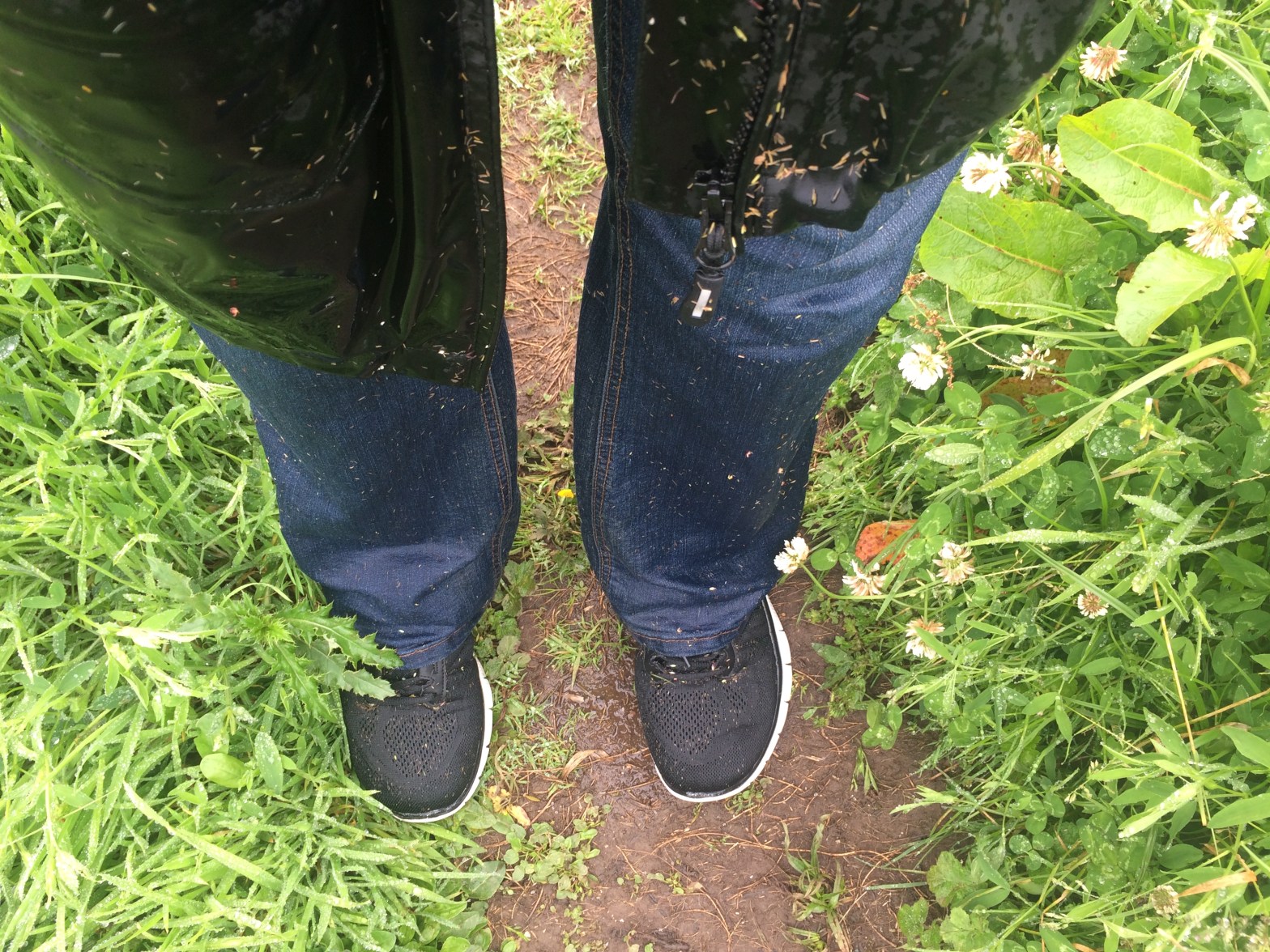
Setting off from Boarhills there is a lot of long grass – very wet grass! As you can see my jeans and shoes were soaked – and that was only after 10 minutes! It had turned into a nice warm day though so I wasn’t worried. I knew I’d dry out once I was out of the grass.

I started where I had left off the night before. It’s easy to miss the sign as you are on a track around a farm and you can easily just keep in walking round the track if you’re not paying attention:

IMG_4578.JPG

So, at this ruin you have to come of the track, turning right across the fields (this is where you start getting wet knees:-) ) and down to the coast:

IMG_4579
IMG_4580
IMG_4581

It’s not long until you reach the impressive Buddo Rock. It’s really massive with a strange  wrinkled surface and what looks like a stairway inside. Quite a site to behold!

IMG_4583
IMG_4589

After this rock the path seems to disappear again so it’s very easy to lose your footing – be careful!

The path is also going up,

IMG_4591

and down (these steps were really slippy!),

IMG_4594

and up again!

IMG_4596.JPG

But when I reached the top it was nice to see some humans on the path coming in the opposite direction:

IMG_4597.JPG

This is (from left to right) Peter, Roddy and Jake. They were out for a days walking from St. Andrews to Kingbarns. They had intended going up a hill but with the weather not so good they decided to walk the coastal path instead. They were saying that it was difficult to find the signs and they’d missed one so and had a bit of an extra trek. Tell me about it!:-)

It was really nice to speak to them. To hear about the difficulties they’d had and how they got round them. I’d definitely recommend walking in a group rather than on your own.

Anyway, on I went over the wall (cute little ladder:-) )

IMG_4598.JPG

and back down to the beach.

IMG_4599

I had now got to the point that I was worried about from the night before:

IMG_4600

and I was so glad I hadn’t attempted to pass it at high tide. It’s basically rocks that you have to climb across and since they were all pooled with sea water I guess it’d be completely impassable at high tide.

IMG_4603.JPG
IMG_4602

After climbing these I passed by Kinkell Ness with it’s rock and spindle,

and was soon being presented with magnificent views of St. Andrews.

At St. Andrews I got a brilliant surprise!

IMG_4614

My daughter Lisa had come to meet me and walk with me for the day! It was a lovely surprise and made the rest of the day feel like a holiday – thanks Lisa (she took a brilliant video of me when she jumped out on me but this version of wordpress won’t allow video – aww shame)!

St Andrews is a lovely town with lots of historical buildings, places to eat and drink,

and of course its famous golf course.

IMG_4621

(apparently this bridge on the course is very famous)

IMG_4620.JPG

After stopping for some lunch we returned to the path to head for Gaurdbridge and then Leuchars. The path at this point is simply a cycle path (watch out for those bikes!) that runs alongside the main road the A91 so there’s not much to see,

IMG_4622.JPG

so I was really glad of Lisa’s company along the way.

I thought this was a nice sign to Guardbridge,

where we stopped for some refreshments:-)

IMG_4632.JPG

It’s only a mile and a half to Leuchars from Guardbridge so it didn’t take us long at all. Leuchars is, of course, famous for its RAF base.

When you get there you have to be vigilant in watching for the Fife Coastal Path signs (a bit small in comparison to other signs!).

There are a few meanderings in and out of streets to get you to the correct place for your walk through Tentsmuir Forrest but when you see St. Athernase Church ahead, you have to turn right into Wessex Avenue then right again onto Earlshall Road. From there you are on the path to Tentsmuir Forrest.

It was a lovely day walking from Boarhills to Leuchars mainly because I had company. I had also decided to make today a shorter day as I had walked a lot of miles each day previously and felt I was not giving myself enough time just to enjoy each place . At 11 miles it was just about perfect – allowing time to sit and enjoy the location and explore some of the sites. It’s not a race after all!

I hope you are enjoying reading my blog – thanks for reading!

Day 6 – Leuchars to Newport-On-Tay

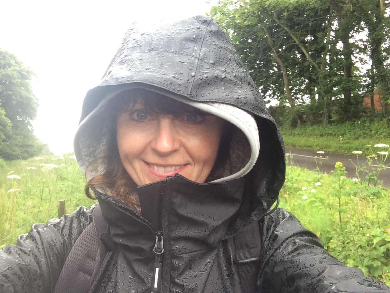
As you can see, today was very wet! Even in Summer a good waterproof jacket is a must – thank you to Gordon Balfour for mine:-)

I started the day at Earlshall Road, past a very nice house,IMG_4635

and up the lane to Tentsmuir Forest.

IMG_4636

Tentsmuir Forest is lovely! A great place to go for the day when the weather is nice. There are loads of different trails to follow, a place to have a picnic, a Crepe Shack (what more could you want:-) ), toilets and the most massive expanse of beach I have ever seen. Apparently seals are often seen there on the sandbanks but I never saw any unfortunately. A lot of people go there for the walks but also to cycle with their mountain bikes.

The problem with Tentsmuir from my point of view was that the Fife Coastal Path signs were not very visible! I was hardly in the forest five minutes and there was a junction of two possible routes but no sign posts!

So, I just took the one straight ahead. I walked for quite a while and eventually came to a sign (phew!) leading onto the beach.

IMG_4641

Now, there was still a path through the forest but there was no arrow on the Fife Coastal Path sign so I assumed I was to go onto the beach although that’s not what my map was telling me! Anyway onto the beach I went (you can’t go wrong on the beach I thought).

And what a size of a beach! It went for miles,

IMG_4644.JPG

and miles!

IMG_4646

I passed a few people on the way – a man flying a kite as he sang ‘Let’s go fly a kite, up to the highest heights…’ that was nice:-) (He did have a child there somewhere but I think the kite was for him really:-) );

IMG_4650

and a couple with five collies racing up and down!

IMG_4647

The rain (that had stopped for a while) started to come down in earnest so I headed off the beach where I saw some people coming in. A nice lady told me that was where the car park was – the centre of Tentsmuir, so I made my way towards it in hope of finding some definite signs for the route I should be following.

The car park is where all the amenities are – the routes for walking/cycling, the toilets and Crepe Shack etc. so I stopped there under a shelter to have lunch and check where I was going next.

IMG_4652

You can just see the pointy roof of the shelter in the photo (above the white car) where all the walkways are displayed. Luckily one of the walkways is also marked as the Fife Coastal path route so I was happy that I finally knew where I was going and set off after lunch determined to get through the forest and onto Tayport.

I started at 12:30 on the fir cone trail:

IMG_4653

past the ice house that was used in the 1800’s to store Salmon (so far so good),

then I’m not sure what happened because there seemed to be an awful lot of paths and trees for what was supposed to be a half hour walk!

Eventually, at about 2:20pm I reached the exit gate, hurrah (thought I was never going to get out of that forest:-) )!

IMG_4666

And on to the pretty harbour of Tayport.

A family I met in Tentsmuir car park had told me I must go to the Harbour CafĂ©  in Tayport and I’m glad I did! A cosy cafĂ© with lovely cakes and coffee. The staff were very welcoming too and left me alone on my laptop to use their wifi (I still needed to find a place to stay for the night – I’d decided to do the seventh day instead of trying to squish the walk into six days). A lovely place to dry off and rest for a while.

The walk from Tayport to Newport-On-Tay takes you through a tree-lined lane,

IMG_4670

then out onto the coast offering nice views over the Tay and of the Tay Bridge.

As they are only three miles apart it isn’t long before you can spot Newport-On-Tay,

IMG_4677.JPG

with its lovely old stone houses, most of which were built before world war 11,

with their views over the River Tay to Dundee.

IMG_4675

I also passed a very colourful bandstand,

IMG_4681

and a war memorial for all the people from Newport who had lost their lives in the second world war.

There is a chip shop in Newport-On-Tay called The Silvery Tay which was highly recommended by my daughter Lisa who swears it’s even better than the one in Anstruther.

Newport-On-Tay was the end point for Day 6. I was very lucky to get hold of the number for a luxury B&B in Newport – The Lillian Bay B& B – owned by a lovely lady called Jackie who gave me a special rate for the night. The accommodation was huge and extremely comfortable so I was very lucky. Thank you Jackie!

Another lovely day was had walking the Fife Coastal Path with its diverse terrain and interesting landmarks. Only one more day to go – who knows what I’ll see tomorrow. Thanks for reading!

Day 7 – Newport-On-Tay to Newburgh

My final day had arrived! I was both looking forward to the end and not wanting it to end. As I came down the hill from my B&B the house above was the first house I came to, looking out over the River Tay – isn’t it lovely?! If you fancy a house looking out over the river then this ones for sale – looks like it might need a bit of work though:-)

Or how about a yellow castle?

IMG_4696.JPG

Newport -on-Tay is so interesting because of its many unusual buildings and very pretty as it’s made the most of the views over the river giving its visitors and residents many places to sit and relax. I passed by this little hidey hole on my way out of the village. You can just see a lady sitting with a buggy.

IMG_4695

Wormit is the next village along (only about a mile) from Newport-On-Tay and very similar with its pretty views over the water.

You will quickly find yourself walking under the bridge and on to Wormit Bay – a favourite for dog-walkers.

IMG_4701
IMG_4703
IMG_4704

As you follow the path from Wormit bay to Balmerino you will pass by a sculpture of a seal put there for walkers to sit on apparently – there is supposed to be three of these sculptures along the path but I only saw one so keep your eyes open – you might just see a real seal in the water too!

IMG_4706

After leaving the coast the path takes you through woodland all the way to Balmerino (about three miles). Its very pretty but slippery too so be careful!

Once you get to this gate you then that’s you reached Balmerino,

IMG_4714.JPG

which is basically just a row of houses.

IMG_4715

Now, I hadn’t expected it to be so small! I was counting on Balmerino to provide me with some lunch, but I hadn’t quite had this in mind.

IMG_4719.JPG

Something cooked preferably or even just a sandwich? Nope. No shops, no cafe’s, no road-side burger vans:-) So, if you do this part of the coastal path, remember your packed lunch!

After Balmerino the path basically takes you through woodland (must have been a strong wind that day!),

and farmland,

and back to woodland again.

IMG_4732

On this path above you come to a Fife Coastal Path sign next to a wee wooden bridge leading into the woods so it looks as if you are meant to go into the woods but I tried it,

IMG_4733

and there were fallen trees all over the path so I just went back to the main path again. And at the top of the hill beside the lovely view was a very welcome sign.

Only 7 miles to go! But as you can see that’s not the Fife Coastal Route path – it had other ideas. It wanted to take me on the scenic route so instead of turning right here you must go straight ahead continuing up the main track road across farmland.

IMG_4736.JPG

So, I might have mentioned before I’m a bit wary of cows – well this is an example of why.

I went past this field of cows and one cow was staring at me all the time:

IMG_4737

So, I politely repeated hello, as I walked past. As I did so, one by one, the other cows looked up and then they all started running towards me, really fast, arrrgh!!

IMG_4738

So, I walked a bit faster not sure what would happen when they got to the fence where thank goodness they stopped. And stared.

IMG_4739

As I walked along they ran along beside me!

IMG_4741

No wonder cows freak me out! What kind of freaky behaviour was that?! Maybe they thought I had some hay in my backpack:-)

Anyway, back to the path. That field is just before a place called Creich which has a ruined castle and a farm basically (no shops or cafes:-) ),

oh, and some pretty cottages where the people there seem to wear an awful lot of t-shirts:-)

IMG_4744.JPG

After Creich there is another tiny village called Brunton – just very pretty houses (no shops or cafes – I did walk down to the village in hope:-) )

and then Pittachope, just a couple of houses (no shops or cafes – get the idea:-) ).

At this point I was a bit tired and hungry after walking around 9 miles and I did consider knocking on a door and asking for a cup of tea and then I remembered the biscuits! Hurrah! The night before I had bought a packet of DOUBLE chocolate digestives to have with a cup of tea in the evening in my B&B. I also had half a bottle of water. I was laughing:-) I sat down on the grass and had my lunch – double chocolate digestives (don’t forget the double – vitally important:-) ) and some water. Just what I needed for the 8 miles left to go. ( I wouldn’t advise this lunch by the way – remember to pack yourself a better one:-) ).

After Pittachope there are no villages – just woodland and farm land for around 7 miles until you reach just outside of Newburgh. It starts off leading you towards the woods up on the hill so quite a climb, but worth it:-)

IMG_4753
IMG_4754
IMG_4756

The woodland walks are very pretty, with the sunlight dancing through the leaves of the trees, and also uphill and downhill –  so it gets you puffing – but, again, worth the effort when you emerge from the woods to amazing views.

You’ll pass by October Cottage,

and lots of fields!

But I did see a very beautiful Thistle would you believe?!

IMG_4766

Just before you emerge from the farmland and into Newburgh the map instructs you to ‘Use the route through field to avoid farm yard.’ Well this should read ‘fields’ as there were at least three with gates that wouldn’t open so you need to climb over them – I must have looked a funny site:-) Unfortunately the fields contained livestock. The sheep were fine,

and some really pretty scenery lulled me into a false sense of security and the feeling that I was done with the fields and heading home,

and then I faced this, with nowhere to go but through them, they were making a terrible noise!

IMG_4782

Panic! I texted my daughter who helpfully texted back hysterical laughter, hahahahahaha. So, I was very brave, head down, avoiding eye contact I walked through the field at a steady pace as not to appear too scared:-) And they ignored me! Never thought I’d ever do that – probably never will again:-)

After this was another field of sheep and then a field of horses (you’ve got to be kidding!) until I passed the farm and  reached the main road that passed by Parkhill.

With only a mile to go I was very happy and who should I meet on the path?!IMG_4784

My husband, Mark! What a lovely surprise. It was very nice to have someone to walk with on the last mile! Thank you Marky – (he’ll probably never read this:-) ).

After all the farmland it was also nice to see the water once more,

and some civilisation too.

IMG_4791.JPG

But don’t get too excited – there are still a few signs to follow:

IMG_4793
IMG_4794

After this one above you have to go into the park – there’s nothing to tell you to do that – lucky Marky was there!

IMG_4795

And once your in the park your onto the home stretch – just follow the path up,

IMG_4796

and around,

IMG_4797

and then you’ll see it just in the distance. At this point you are allowed a big smile:-)

IMG_4798

and before you know it,

you’re there and walking under that big arch! (and hopefully you won’t look as much as a state as I did:-) )

IMG_4802

Hurray!!!

And that was the walk over with – 117 miles of rugged landscape, interesting landmarks, historic buildings, warm, welcoming villages with their cosy cafes and B&B’s and, of course, beautiful coastline. Missing it already!

Some tips I would like to leave you with just in case you decide to see it for yourself one day:

  • Take waterproofs.
  • Take sunscreen.
  • Take a packed lunch wherever the map/guide indicates the path is quiet/rural roads/forest.
  • Take a friend/s. To have someone to share the experience would make it even better, I think.
  • Pace (1). When planning how many miles you will cover each day think about the terrain. Look at the guide. Walking on normal pavements is so much easier than hiking across long grasses and rocky beaches.
  • Pace (2) Also, you aren’t going to be able to walk at the same pace on day 7 as you did on day 1 when your legs are fresh.
  • Check the tides and where the map says ‘not passable at high tide,’ believe it:-)
  • Be vigilant when looking out for the Fife Coastal Path signs – they are there if you look for them most of the time ( I commend the work of The Fife Coast and Countryside Trust who manage and maintain The Fife Coastal Path and do an amazing job considering the extent of the area).
  • Last but not least – take your time! There is so much to see – give each town and route the time it deserves. I would say ten miles a day is more than enough. Explore and enjoy it!

I hope you have enjoyed sharing some of the sites around the Fife Coastal Path with me. I certainly enjoyed doing it. Thanks for reading!